One aspect of yesterday's extensive thread entitled "Of Lawsuits, Tunnels and Tall Trees" that I feel did not receive enough attention is the matter of knock-on effects of grade separation strategies and, that of where CHSRA will put the mid-peninsula station. Other than the tentative Hanford/Visalia/Tulare station, this is the only one that CHSRA has not nailed down yet.
Knock-On Effects of Grade Separation Strategies
In deciding which type of partial or full grade separation they want to see implemented, the mid-peninsula communities of Redwood City, Atherton, Menlo Park and Palo Alto need to negotiate not just with CHSRA but also with each other. Once HSR becomes operational, there will be three railroads in the peninsula corridor: Caltrain, HSR and Union Pacific. ACE and/or Amtrak (Capitol Corridor, San Joaquin, California Zephyr, perhaps even a Coast Corridor sleeper service from SF to LA until HSR is available) could conceivably seek limited trackage rights up to 4th & King in San Francisco in the future, especially if and when the old Dumbarton rail bridge is restored to active service. That means the grade separation solutions in the mid-peninsula must also consider the need for turnoffs toward that bridge at the border of Redwood City and Atherton.Serving everyone's needs requires that the gradients of at least the Caltrain tracks be kept low enough for freight trains (2.2% max) and, that all stations be on level track sections. Keeping everything at grade achieves this nicely, but it would also make full grade separation of the corridor more expensive and intrusive for properties adjacent to both the tracks and the cross-roads. That means it is not technically possible to elevate tracks in Menlo Park and not do it in downtown Palo Alto as well. Likewise, you cannot run tunnels under just downtown Palo Alto. The impact of the level at which tracks will run near the San Francisquito creek extends as far north as Redwood City and south to at least Oregon Expressway in Palo Alto, if not further.
CORRECTION: Except for deep tunnels under San Francisquito Creek, it appears there is in fact enough run length to accommodate a mix of grade separation solutions without turning the alignment into a roller coaster (h/t to Clem).
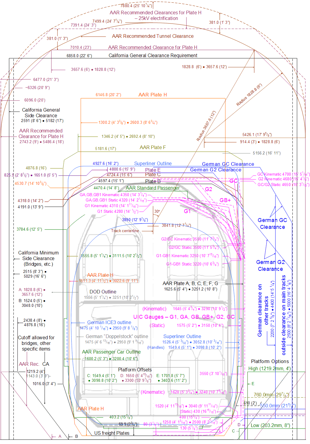
The Port of San Francisco has asked Caltrain to enable the operation of extra-tall AAR plate H freight cars, e.g. for transporting imported cars stacked not two but three high. It may be a serious case of the tail wagging the dog, but this wish might nevertheless be granted, e.g. as part of a grand bargain with UPRR on an ROW deal for SJ-Gilroy or, with the city of San Francisco on CHSRA/JPB contributions toward the DTX tunnel to and trainbox under its new showcase Transbay Terminal Center.
The overhead catenary system would have to provide not just physical but also electric clearance for plate H freight trains. The latter refers to the minimum vertical distance to the 25kV overhead catenary system that is required to avoid electric arcing (i.e. short circuits). This is especially critical at overpasses and in tunnels.
Any new long covered trenches or tunnels in the corridor might therefore have to be taller than required for Caltrain and HSR alone. Extensive undergrounding would also introduce another safety concern, as diesel-powered freight trains would need to run through several underground stations. EPA is tightening emissions regulations for remanufactured and new diesel locomotives, but all California rail operators have large numbers of dirty legacy units.
UPDATE: Retrofitting diesel locomotives with pantographs to avoid diesel emissions in tunnels is possible, but someone - e.g. the cities demanding that tracks be put underground - would have to pay for that, in addition to the much greater cost differential for a drilling four long, large-bore tunnels in the first place.
HSR Station Options
In addition to track work, the city that gets the mid-peninsula station will have to deal with the mixed blessing of becoming a regional transit hub. The primary challenge is figuring out how to manage - or better yet, avoid - additional car traffic by offering connecting transit and bicycle infrastructure, while eliminating free parking in the station environs. Below are maps that showcase the kinds of issues urban planners will have to deal with when HSR comes to their town.Officially under consideration are Palo Alto and Redwood City. The former already generates more Caltrain traffic than San Jose. The latter is arguably better located for (connecting) service to and from from the East Bay, though that argument has been weakened by the decisions in favor of Pacheco Pass and the BART extension to Santa Clara.
Nevertheless, since there will be no HSR service between San Jose and Oakland in the foreseeable future, bus feeder services across the Dumbarton road bridge will have to be offered to avoid excessive additional traffic near the station areas. Another complication is that both candidate locations are located near shopping centers that offer ample free parking, intended for use by their customers. It is entirely possible that HSR passengers arriving by car would abuse these parking lots. One possible workaround is to always require motorists to pay for parking near the HSR station. Retail outlets would then validate the first hour or two for customers that spend above a threshold amount. Any surplus would be used to help subsidize local and regional transit services, which after all bring in not just rail passengers but also customers from further afield.
In addition to bus or streetcar services and for-fee car parking, Caltrain/HSR combo stations need to provide ample for-fee parking for bicycles - preferably guarded or based on biketrees to curb theft and save space.
The chosen host city should also provide safe bicycle access routes, as is common practice in e.g. Houten (Holland). Bicycles are emissions-free and use road space more efficiently that four-seater cars that are - let's face it - most often used to transport just one or two persons. Cycling therefore ought to be a popular way to catch any type of train, especially in summer when air quality is at its worst and gasoline at its most expensive.
City bikes with electric assist systems, already all the rage in China and parts of Europe, greatly increase the bicycle catchment area for train stations, in terms of both distance and terrain. It may even make sense for cities and passenger rail operators to encourage the purchase of folding models, possibly with electric assist, as these can more easily be stowed on trains and even, recharged. That would increase ridership and reduce demand for bicycle storage.
Another option are fleets of sturdy conventional bicycles that people can rent at no or very low cost, e.g. Velib' in Paris (France) or CityBike in Vienna (Austria). However, their success depends largely on high population density and flat terrain, a combination in short supply in California, though Palo Alto might qualify.
To illustrate possible solutions for the candidate locations for the mid-peninsula HSR station, I have prepared three exploratory maps. These do not reflect any official plans from any agency or city.
Note that these do not show the details of the station layout, e.g. side vs. island platform(s). The Caltrain HSR Compatibility Blog is a more appropriate venue for those. All I intend to highlight here is the need to accommodate four tracks, of which at least two must have two full-length (1/4 mile) level boarding platforms. Even if these are not fully built out right away, the space for them must be reserved up front, as must adequate room for pedestrian flow into and out of the station on both sides of the tracks.
Keep in mind that CHSRA could still decide to cancel its plans for a mid-peninsula station altogether in the context of the project-level EIR/EIS for this segment of the HSR route.
Option 1: Redwood City
View Larger Map
Note the existing Sequoia Station's proximity to a large shopping center and the city's main street, Broadway. The map also shows the convenient access to the business park at Network Circle and the Dumbarton bridge beyond it, as well as the turnoffs for future commuter rail service across the bay.
The bus route to Union City is indicated in orange. A new bus terminal next to the station could feature a publicly accessible green roof that would serve as an additional small park. The building could feature a second story with transit-oriented offices or else, support services for transit users/shoppers: a post office, a supermarket, dry cleaning, a day care center with for-fee reservation by the hour etc. Just for kicks, I also sketched (in red) a streetcar route that would link the station to several business parks in the area. There is a legacy rail ROW out to Seaport Blvd, but otherwise this is just an crazy idea of mine.
Option 2: Palo Alto
View Larger Map
Note the proximity to Stanford University, Stanford Shopping Center and the city's main street, University Avenue. The latter has already been grade separated against the railroad tracks as well as Alma St. and El Camino Real (see Focus On: Palo Alto). Both the rails and Alma St. were moved west some 85 feet to ease construction of the underpass. The resulting chicane would prevent HSR express trains from passing at 125mph. The existing station building will also have to be moved or replaced when the alignment is straightened out again. That means the Alma/University interchange will also have to be extensively modified unless the rails are moved into very deep tunnels with sufficient overburden at the underpass, which would open up a can of worms (see above).
If the rails remain above ground, it might make a lot of sense to leverage two of the existing connectors between the two roads to return Alma St. to grade level, but with a chicane in the other direction. The space in-between would be used for modified turn-offs into and out of the underpass.
In addition, the map shows a more radical idea that is not at all essential to HSR operations but in keeping with the transit-oriented spirit of the project: converting the section of University Ave. between the modified Alma St. and Webster St. into a pedestrian zone with al fresco dining etc. A single traffic lane down the center would be retained for vehicles with a permit, e.g. police, fire, ambulance, sanitation, handicapped transport and delivery trucks at certain hours of the day. Normally, it would be reserved for bicycles. All of the parking spots would disappear, motorists would need to make do with the parking lots along Lytton and Hamilton. Local traffic, possibly including a courtesy shuttle to the Caltrain/HSR station, would be routed around the pedestrian zone via these roads plus Webster and Alma. The European experience shows that shopkeepers' fears about losing foot traffic are misplaced, as shoppers actually flock to pedestrian zones within easy walking distance of transit stops and/or parking.
Vehicular through traffic would be encouraged to use the existing one-way express streets Homer and Channing, located several blocks south-east of University Ave.
Another feature of the map is a bus terminal located next to the station. An existing nearby restaurant could be relocated to the second floor there to make room for a nice plaza in front of the station, for drop-off/pick-up and taxi waiting service. As in Redwood City, the bus terminal building would feature a green roof, part of which would be used for al fresco dining in this case.
Also note the optional two-story car park at the north end of the station platforms, with a publicly accessible green roof to replace the soccer pitch and corner park that would be lost during construction. Alternatively, capacity could be added across the street at Stanford Shopping Center by adding a second story there, iff Stanford Shopping Center is amenable to that.
The final feature worth pointing out is the red area opposite El Camino Real from the station. The land is owned by Stanford University, which could decide to develop it for a transit-oriented hotel-and-conference center for visiting academics, cultural venue and/or affordable housing for graduate students. This is optional and not at all essential for the success of the HSR station.
Bonus Option: Mountain View
View Larger Map
This city is currently not under consideration for the mid-peninsula station, perhaps because that would give Santa Clara county three stations vs. just one for San Mateo county. Nevertheless, the location may be worth considering for three reasons:
a) VTA Light Rail already connects Mountain View to the "Golden Triangle" of Silicon Valley, a collection of high-tech businesses in the area bordered by I-101, 237 and I-880. The existing light rail track(s) will have to be moved to permit construction of two dedicated HSR tracks - if not up front, then definitely at a later date. Since the light rail approach to the station is single-track, one option would be to move that to the median of Central Expressway, terminating in Stierlin Rd. A pedestrian overpass would facilitate access to the train station.
b) The location is close to several major highways: I-101, Central Expressway, 85 and 237 plus, the area's largest employment and entertainment cluster - Shoreline - is near the shortest route to Dumbarton bridge. That means Mountain View arguably has a larger catchment area than even Palo Alto, which may explain why it already attracts almost as much ridership on Caltrain.
c) The city of Mountain View has been pro-active in planning ahead for the arrival of HSR tracks (h/t to Clem Tillier).
The town's main street, Castro, currently features a busy grade crossing. Existing overpasses in the area preclude elevating the tracks and, a deep underpass would be disruptive to the station and other properties near the intersection. The map therefore shows Mountain View station remaining at grade with the crossing permanently closed! A drastic step, to be sure, but one that may be required for HSR even if its trains end up just passign through.
To compensate for the loss of access to Central Expressway in particular, traffic would be re-routed via N Shoreline, W Evelyn and Whisman. Also shown are alternative access routes to and from 85 and 237 that skirt residential areas. With road space at a premium near the station, traffic is already constrained northbound at the station. Note that the direction of traffic flow around the bus stop circle might have to be reversed. However, there is no room right next to or across Central Expressway from the station for a bus terminal, as in the other two locations.
Also shown is the option of turning three blocks of Castro St, a popular local destination for lunch, into a pedestrian zone with traffic routed around it via side streets. Note that there is no large shopping mall near this station.
Finally, note the existing bike lanes and dedicated path out to Shoreline business park (Google et al), amphitheater and lake. The path extends all the way to Palo Alto airport. Unfortunately, N. Shoreline is too narrow to permit extending VTA light rail all the way out there, so concertgoers arriving by train will have to hop on the bus across to Union City instead. It should use the frontage road to avoid I-101, which is often congested.

54 comments:
Long Island Railroad and Metro North, just to use two examples, both have been using dual mode locomotives, which normally run as diesel-electrics, but can switch to all electric for trips into Manhattan, for decades now. I know you hate the idea that the peninsula might get a tunnel for HSR, but the "diesel freight trains can't run in passenger tunnels due to air quality" is kind of a non-starter.
@ anon -
I'm perfectly aware of the existence of bi-modal locomotives, but are you going to reimburse UPRR for the retrofits? Because they aren't going to volunteer the funds and neither are California or federal voters, unless it becomes necessary in the context of an ROW deal with UPRR for another part of the HSR route.
Also note the gradient and AAR plate H-related minimum diameter of the four (!) tunnel bores that would be required. If you want to pay for the incremental cost of those, fine. Just don't expect anyone else in California or at the federal level to do so, because a tunnel alignment through suburbia adds zero value for them. See BART extension to SFO for details.
Rafael, some interesting thoughts there. A couple of reactions:
(1) there is enough run length between the San Francisquito creek and Ravenswood Ave in Menlo Park to accommodate any combination of grade sep arrangements at either location.
(2) the Palo Alto station building in on the outside of the double reverse curve, so it does not need to be moved.
(3) there is no need to touch El Camino park in Palo Alto. This will only inflame the opposition.
(4) the station in Redwood City would more logically be built north of Broadway. There's lots of room and much of the land is already owned by transit agencies. If the station were elevated, Broadway would become whole again.
The more I think about it, RWC makes a lot more sense than PA for an HSR stop. Rail ridership at PA only looks so good because the other stations have such lousy numbers; it is not necessarily indicative of PA being some sort of hub.
(5) I believe there is just enough run length between Castro (MV) and the Hwy 85 overpass to allow a split grade separation at Castro. Closing Castro is going to be a non-starter.
@ Clem -
there is around 4000ft of usable run length between the San Francisquito Creek and Menlo Park. At 2.2% gradient, that's enough to accommodate a difference of 88 feet, which would indeed be plenty for most of the transitions under consideration. For example, tracks could remain at grade in Palo Alto and run partially elevated for split grade separation as suggested by CHSRA's consultants, HNTB. Or, they could descend into a shallow or deep trench, a solution the city of Menlo Park has proposed in the past.
The one exception would be a deep tunnel underneath the creek, which could not emerge back to the surface until well north of Menlo Park station. Tunnels under bodies of water need sufficient overburden to prevent flooding during construction.
But then, some residents of both that city and Atherton now want tunnels anyhow. By the time the alignment reaches the border with Redwood City, those could have become (partially) covered trenches, still an expensive solution but more manageable for the turnoffs to the Dumbarton bridge.
As for Mountain View, a split-level grade separation at Castro might well be possible, there is about 1300ft of run-length between the N Shoreline overpass and the intersection. That's enough for 28.5ft elevation change at 2.2% gradient.
Perhaps the more pertinent question is if Mountain View wants to use HSR as an excuse to sharply reduce through traffic down Castro St. itself to attract more shoppers/diners and inward investment to its as-yet small downtown area.
Youre blithley and ignorantly talking about devastating impacts to the bread and butter of these communities (talk about changing traffic patterns, street closures, access to vital down town areas, destruction of parks and historic landmarks, etc.)
I love the idea of turning these shopping centers' parking lots into 'for fee' parking to avoid HSR parking. Really, brilliant. We'll forward your bright idea to the merchants at Stanford Shopping Center immediately. I'm sure they'll be all for it.
Bikes: It obviously is of no interest to you at all that towns up and down the Peninsula have tried everything they can imagine to encourage bike usage. So assuming these towns suddenly convert wholesale to bike traffic, just to get around for HSR's sake, just really so poorly thought out. Childish really.
"Ample for fee parking for bicycle". Really? There's ongoing community conversation that says in fact that they don't need to PARK bikes at the station, but rather the trains need to accomodate significantly MORE bikes ON THE TRAINS, in order to make bike commute even halfway feasible. Because what happens when you get off the train? Well in dense European towns, something, but in the Peninsula, not much without significant time or money. Its already been studied, been tried and been found that its NOT happening.
And long distance travelers that would be going on a longer trips (afterall HSR as a replacement for Air travel is the whole idea isn't it?) aren't hauling luggage and kids on bikes to the station. (The EIR says 52% of all travel between LA and SF is recreational...) The whole 'lets all get on bikes' concept in these spread out towns, not happening.
As for the idea of shutting off the ENTRANCE to University Avenue (from the Alma side) completely for through vehicle traffic - brilliant example of an utter lack of understanding of the flow of the town, the nature of the customers to University Avenue, and the importance of a through traffic flow to this very narrow commmercial street. There is a HUGE flow of customers from Alma to Unviersity - to cut that off would be basically death to University Ave commerce.
"One way express streets Homer and Channing" WHAT? These are one or at best two lane residential streets, that are lined with STOP SIGNS, unregulated cross walks, lined with stree parking on both sides, not even wide enough for bike lanes in some cases. And the feeder entrance to those streets is MIddlefield, another primarily residential and already highly impacted thoroughfare. You're going to route major commercial traffic through residential neighborhoods now?
This is all such sheer nonsense here its not even worth poking holes in, but the people who are your cult followers REALLY need to begin seeing that you don't know what the hell you're talking about when you come up with thise wild ideas that basically remodel entire towns and people's livlihoods around HSR.
And by the way the existing nearby restaurant that could be relocated to the second floor of a parking garage? - an historical landmark building, that won't be touched. Period.
Closing off access to Mountain View's historical downtown Castro street. Wow, amazing.
Again, alot of free flowing creativity here with an area you understand almost nothing about (except vaguely on paper), and frankly its ovbious you have no interest in, other than as a receptor how best to clear cut for HSR.
@ anon @ 4:29pm -
as I said, turning part of University into a pedestrian zone is not a requirement. You can keep it open if you want to, but you will be depriving merchants of a golden opportunity to increase foot traffic. Bicycle traffic into downtown, e.g. from Stanford, would probably increase if there weren't any cars around. But I digress, this blog is supposed to be about HSR.
The fact is, iff the tracks remain above ground - as I have assumed throughout for the purposes of these maps - then the chicane will have to be straightened out again regardless of where the mid-peninsula station end up. That means Alma Street will have to be as well. It would be possible to construct a hump across University to ensure adequate clearance for the approach to the underpass. There might be consequences for the gradient of at least two of the connectors between the roads.
But your comment does underline one fundamental issue with choosing Palo Alto as the site of an HSR station: none of the streets is really wide enough to accommodate significant additional traffic between 101 and the station. Not University, not Willow over in Menlo Park, not Middlefield nor Lytton, Hamilton, Homer or Channing.
In particular, additional car traffic from the East Bay could pose significant problems, even if traffic management of one type or another were successful in spreading the load. The BART extension to San Jose should alleviate the risk to some extent, since every HSR train will stop there but only a fraction in the mid-peninsula.
Still, I'm not suggesting that "major commercial traffic", e.g. heavy duty trucks, ever be routed through residential areas. Afaik, they are still uncommon on University Ave today and it seems unlikely that truckers would change their mind on that. Bus traffic along Lytton and Hamilton would increase, but only to give motorists an alternative.
Oregon Expressway could easily take whatever extra road traffic HSR might bring, but I'm not sure it would be particularly useful to site an HSR station near there. The whole point is to have stations in the downtown areas of the cities served.
And btw, I do know Palo Alto and Mountain View quite well since I lived and worked in the area for a number of years in the 1990s. HSR coming to the peninsula is a major change, the challenge is to figure out how to make it one for the better within the available budget.
Another voice here for taking more seriously the complaints of those on the Peninsula. Palo Altans have worked very hard over 15 years to get kids to walk or bike to school instead of driving. More than 50% of the kids in middle school and high school "cross the tracks" every morning. Every iteration I've heard (tracks up, street up, street down, street closed) would seriously mess with this. While intuitively a grade-separated crossing would be safer, it's not. Cars speed up significantly going through any underpass that even vaguely reminds them of going under a freeway (the only exception are cute little English village bridges). This speedup makes routes that were safe for kids unsafe. Closing roads increases traffic on other streets with a similar impact. Churchill, Meadow and Charleston are bike highways at this point. The bike route to one of the high school is parallel to the tracks and disappears according to all CAHRA engineers I've spoken to.
The California Zephyr does NOT serve the peninsula. The Coast Starlight does, instead.
Although i do not agree with the tone of the Anonymous comment, I do agree that some of these ideas can not and should not be part of the HSR project. Moreover I think that dismissing the concerns of the local residents by saying "it has been there for 120 years so they have no say" is completely irresponsible and should be stopped. If we like it or not this is a large change to the communities that it will go through, even though the ROW predates the cities. Yes most people voted for the project in these areas, but that doesn't mean the people affected are out of luck, nor should their concerns be brushed off. Opponents can have another agenda, but if they bring up valid concerns, they need to be correctly addressed.
Don't get me wrong, I really want this project to succeed, but the "US v.s. Them" attitude needs to stop. It helps no one and makes compromise that much more difficult.
These ideas are mostly academic "What ifs," which aren't bad ideas in their own merit, but unfortunately all this should and will be left exclusively to the community's citizens. Any planning that is not directly related to laying tracks needs to be at the local level, and needs to be at the blessing of the communities.
I think that most of these are straying fairly far from the goal of a viable rail project.
@ anon
When i was in high school, they were constructing the extension to the 210 freeway where i lived, building a bridge on the street that i walked to school.
In that case Caltrans provided a walkway around the construction site so the students could still walk to school. This kind of planning does take place before construction begins and this construction won't be any different.
@ anon @ 5:22pm -
the roads you mention could in theory remain at grade, provided what FRA calls "impenetrable barriers" are installed.
Another suggestion that has been made is dedicated bicycle and pedestrian underpasses, preferably well segregated against parallel road traffic. University Avenue features those, but a crossing used by large numbers of K12 students would need them to be wider.
The split-level solution proposed for Menlo Park might work for the crossings you mention. They would mean shallower underpasses than usual, making it easier and hence safer for cyclists to climb back out again. The downsides are the aesthetics of a partially elevated rail alignment.
@ Mike Wolf -
I know the Zephyr terminates in Emeryville today. Passengers bound for SF need to transfer to a bus. What I suggested is that one the Dumbarton rail bridge goes back into service, Amtrak might want to extend the route all the way to SF.
Amtrak's Coast Starlight runs along the East Bay, not the peninsula. Perhaps you were referring to the Coast Daylight, which is no longer being offer.
I deliberately did not refer to it as such, because I believe the low feasible speeds along the central coast alignment would make it more suitable for a new sleeper car service along the same route, operated by Amtrak California. Thus, it would supplement the Coast Starlight operated by the federal organization.
Whether or not such train will ever be offered is not material to my point: at some point in the future there may be more than three rail operators that are active in the peninsula corridor.
Another thing to consider. Part of the route will go through several Eichler communities. At least one of these has a one story overlay for privacy reasons and is on National Register of Historic Places. It is not nothing to put a 75 foot wide elevated structure through these neighborhoods. A constructive attitude where you try and help think of mitigations would go a long way.
@anon 6:05 PM. While I agree that mitigation should be done carefully and thoroughly, do note that community zoning does not apply to railroad land. Nor do tree ordinances and other local regulations.
The railroad corridor may be free from zoning ordinances, but their impacts on historical surrounding communities will be 'counted' in the project level EIR/EIS (by hook or by crook, these communities will make sure of it) and significant mitigations (likely much more costly than the original thinking in the program level eir/eis) will be required.
All this points to is the fact that rash and underinformed decisions were made on Pacheco Pass/Caltrain route that didn't take full and widespread costs along the Peninsula into account.
A full accounting will likely see Altamont pass route revisted.
Two years and a heck of a lot of 'study' and 'community input' (some in the form of legal action) may be avoidable if CHSR Authority comes to this sensible conclusion sooner rather than later.
I'd rather have an HSR than maybe have my grandkids still fighting over this 30 years from now.
Clem -
While HSR is not subject to zoning, under environmental rules it is under an obligation to try to mitigate aesthetic, noise, shadows etc caused by the project - the impact of which should probably be vis a vis electrified Caltrain which is what residents will get even if HSR doesn't go through.
It can make a determination that these are unavoidable or try and argue that they are no big deal "low" in EIR terms.
HSR is taking a risk in terms of underplaying impacts - these make the EIR contestable and open up the road to reverse condemnation, which could get expensive given shacks cost $1mm in the area.
@ Rafael, I'm not sure why you keep bringing up the idea of "impenetrable barrier" at-grade crossings. Caltrain is talking about increasing frequency 12 tph peak service through this route, in addition to HSR service. At that frequency, you might as well block off the street permanently. I've never heard anyone but you even float the idea of keeping at-grade crossings; I'm not sure why you think it's a viable idea.
Oregon can easily take the added traffic...
Wrong again.
Oregon is already under study by the county for traffic flow improvements because its already a parking lot during commute hours.
The citizens of Palo Alto just succesfully got the county to STOP some Oregon expressway widening "improvements" that would widen the road, create barriers from turns (that would increase throughput on Oregon), that would cut down some trees and landscaping strips, that would reduce bike usability in favor of faster moving traffic, etc. They got it all thrown out. The new "improvements" now will be all about reducing traffic flow through, increasing bike and pedestrian safety. retaining and increasing landscaping and sidewalks for pedestrians.
Also be aware that Palo Alto is in process of adding a much needed elementary school which will require a significant number of K-5students to cross Oregon. The residents of Palo Alto are already arming on this issue.
The days of Oregon being a fast route through/across Palo Alto from 101 to El Camino are gone. Don't be surprised if you see the towns looking for ways to reduce the number of lanes, and get traffic slowed down significantly there in the near future. PA is definitely NOT going in the direction of town ready to create bus expressways or widened expressways to accomodate massive influx of cars that would be congruent with a 'transit hub' sitting in the middle of town.
Anonymous friends, points well taken. The environmental impact process must be adhered to. And Altamont would have been so much better.
Please educate me: doesn't inverse condemnation require some land to be taken by eminent domain in the first place? In areas where the ROW is wide enough (95% of Palo Alto, and ALL railroad right of way within Atherton town limits), my understanding is that there might never be any basis for inverse condemnation suits. Am I way off base?
The points the Anons are raising (and I would ask you folks to pick a name, even if it's a pseudonym, so that separate authors can be distinguished) are interesting from a best practices urban design perspective.
But the breathless "omg it'll destroy our community!!!" framing is not warranted. Seriously, you want to hold up HSR because you're worried about how your kids will get to school?
Don't get me wrong, that is an important issue for the community. But that's something that can be addressed. Palo Alto can come up with a decent solution. Eliminating grade crossings and closing streets simply doesn't qualify as a significant impact on a community. Those are very manageable impacts.
And that's what bugs me about this whole thing. The comments from the most concerned/upset Palo Alto residents don't indicate a desire to use this as an opportunity to embrace sustainable transportation and pioneer ways to integrate it into their community, serving as a statewide model.
Instead they indicate a desire to try and stop HSR, to try and preserve their community frozen in time.
My comments have consistently called for Palo Alto to approach this constructively, and I want to do the same. But at the same time, Palo Alto cannot deny reality. If they want to be able to commute to other parts of the region or the state, electrified rapid passenger rail is a necessary part of our future.
All these NIMBYs who use 101 or 280 to get around the region and access airports or interstates to take them around the country and the world have a rude awakening in store when that becomes too expensive to continue to do. HSR and Caltrain electrification will help Palo Alto residents save money, save jobs, and save lives.
So much of this HSR denial is based in a refusal to accept that communities change. Palo Alto today doesn't look the way it did 25 years ago, or 50 years ago, or 75 years ago. Change happens.
It is good and right for a community to want to get out in front of that change and ensure it works for them. But it's ridiculous and damaging for us all when they want to deny the need to change.
And really, we are not talking about dramatic changes. The rail corridor is already there and was there before Palo Alto. There's already a grade crossing at the busiest intersection in town. Adding two new tracks and grade separations will produce some changes to the city but they are manageable. They're not the end of the world.
It's time for Palo Alto residents to get real. Nobody here, nobody at all, is treating the city like Robert Moses did NYC. We're imploring residents to propose sensible methods of implementing HSR. We want to know what works. Instead we get HSR denial and folks taking small issues and turning them into huge crises.
It's unnecessary nonsense. HSR can work for Palo Alto. Kudos to Rafael for trying to propose ways it can happen.
Closing roads increases traffic on other streets with a similar impact.
It doesn't. Traffic flow research, as well as examples from the closure of the West Side Highway in New York and the Embarcadero Freeway in SF, shows that closing roads makes the traffic on them disappears. The idea that traffic is fixed and doesn't respond to changes in capacity is mostly an invention of Robert Moses, who wanted to justify road widenings and new highway bridges. He didn't even believe that - he knew that opening new bridges would bring in more traffic, which would enable him to argue for building more bridges, and vice versa. He just said it to get city planners on board.
http://en.wikipedia.org/wiki/Inverse_c
condemnation "quiet enjoyment"
I'm not saying these would be successful but I am saying that the elevated solution, which again engineers looking at the situation with Alma and Park Blvd, put out as cheapest solution is not as cheap as it may seem.
Part of my pique is that I am a dedicated transit user but have had to stop taking Caltrain to SFO as a result of Judge Kopp's folly. Please excuse this.
anon @ 7:53PM
your Wikipedia link does not work. can you fix that please?
yeah i know about Judge Kopp's folly for Bart to SFO.
That's one thing i don't like about him.
anyway it's my guess its one of the main reason for choosing Pacheco Pass over Altamont Pass. I mean if you look at the map for Altamont Pass route you would see that the route branches out in 2 ways, one to san jose and other to umm oakland?? (am i right?).
It makes sense that he would want to avoid making same mistake twice. so he chooses the one that are stright route. thereore we have Pacheco Pass.
To Clem and some of the anon posts,
Repeat 20 times then rinse, followed by another 20 rep's: "Altamont vs. Pacheco is over, and the Pacheco Pass will be the primary HSR route into the Bay Area."
Again, routing into the Bay Area has been decided, and the Pacheco Pass was the right choice.
The question now is where the mid-peninsula station will be located and how HSR will be designed from SF to SJ...THAT'S IT!
Question: Judge Kopp's folly? I am aware from personal experience that the SFO BART alignment is a little odd vis-á-vis the fact that it appears to be designed such that trains were meant to go "through" SFO on the way to Millbrae, but with a reversal required at SFO. Very odd layout, and similarly odd re: Caltrain transfer at Millbrae for an expensive BART ride to SFO.
In short, BART to SFO works great from the city, but appears a little odd from the peninsula, and Caltrain to SFO, uh, doesn't exist unless you want to transfer at Millbrae. Was it not meant to be that way?
@Tony D: it ain't over. If you are so confident that the lawsuit will get thrown out, then there's no reason to get all worked up about it.
More generally to HSR supporters, there's no sense in letting NIMBYs infuriate you like this. Either they don't matter, in which case you ignore them, or they do matter, in which case you need to work with them. Your response conforms to neither of these alternatives, and is therefore irrational. (in my humble opinion.)
@Aaron: Caltrain to SFO used to exist. A free shuttle van met every train and dropped you at the terminal of your choice. One and a half billion dollars later, you have to follow these complicated steps, with your kids and luggage:
(a) Transfer to BART and ride past the airport to San Bruno
(b) Transfer to another BART and ride to the SFO international terminal
(c) Transfer to the AirTrain to get to your terminal.
Bloody brilliant!
And by the way, although I, like Robert, am a little irritated by the breathless comments from the Anons (seriously, at least use your first names or something, this is getting confusing), anon @ 4:29pm does make some good points. We can look at maps all day, but I don't know all that much about Palo Alto. I've always thought that it was pretty important to tell the Peninsula cities that HSR is going to be coming to the community, but that the Authority is happy to discuss the most appropriate way to do it. From what little I know about the Peninsula and my prior time on Caltrain, the existing Caltrain ROW often runs through low-density residential neighborhoods. The fact that some people are using the complications as an escuse to kill the project does not automatically render all concerns invalid.
This is not Metrolink here (which often largely abuts the back of industrial buildings and warehouses), and the Authority is going to have to be cognizant of that fact. CAHSR would do better to look at how the Acela runs through Connecticut and Rhode Island, for a start. Frankly, for the LA - SF route, it seems obvious that the worst of it will come in the Bay Area, I don't expect that Los Angeles alignments will be as difficult or controversial, save for the potential need to reconfigure Union Station.
And on a final note, I am unamused by concerns coming from the freight companies. It is their malfeasance that led to the failure of previous passenger service in California, and I honestly think that it's time for them to get with the program. What is the particular situation? Do freight companies run service on the entirety of the Caltrain ROW? Isn't that going to cause problems vis-á-vis the fact that we don't want HSR and freight trains on the same tracks?
Consider I-280. California Division of Highways hired landscape architects (no less than Halprin) and architects to make sure the freeway was as beautiful as possible. It is a work of civil engineering art.
HSR on the Peninsula (and in total) needs the same attention. If it is coming, what makes it the best for all concerned?
Remember, this blog is the community, not the designers of the system. It is a conversation, not the legal and technical shepherd of the system.
@Clem: So was the SFO Caltrain station closed and moved to Millbrae with the last BART extension?
@Aaron: I'm sorry, I wasn't clear. The airport shuttle van met every Caltrain at the old Millbrae station.
"Cars speed up significantly going through any underpass that even vaguely reminds them of going under a freeway (the only exception are cute little English village bridges). This speedup makes routes that were safe for kids unsafe."
The pedestrian and cycle underpasses do not have to be the same grade as the road underpasses ... f'rinstance, the pedestrian and cycle underpasses could pass through at grade, while the road underpasses are cut below grade in order to provide more clearance.
In terms of the normal HSR station pattern for a large metro area ... outer suburban station, inner urban station, outer suburban station ... doesn't the mid-Peninsula station fill in the "outer suburban" slot both south of SF and north of SJ?
In terms of cycle throughways, a strong solution is elevated HSR with flanking elevated cycle throughway, with the access ramps taking advantage of the space under the elevated section.
Bruce
Do you have some links to examples? I'd love to see these.
Re: Bart to SFO - there was a really simple great solution and Kopp was personally responsible for pushing through another.
Speaking of Palo Alto, there is an existing plan slowly being moved through the process--http://www.smartgrowthplanning.org/PaloAltoIntermodal.html
@ anon @ 6:53pm -
I just pointed out that keeping grade crossings is theoretically possible because FRA rules would permit it for the speed classification that HSR requires in the peninsula. The plan is, quite rightly, to fully separate the grades. Retaining any grade crossings is very much plan B, just in case local communities and CHSRA cannot agree on a grade separation strategy.
@ anon @ 6:59pm -
please understand that I wasn't advocating an HSR station near Oregon Expressway in any case. I was merely pointing out that it's a road that is much better equipped to handle heavy cross traffic than University Ave. is.
It is precisely because of the impact of additional cross traffic that planners are considering at least two other options Redwood City and no mid-peninsula station at all.
@ anon @ 7:53pm -
wasn't it the county of San Mateo that bloated the BART extension to SFO project by insisting on a subway - rather than at-grade - alignment between Daly City and San Bruno? At the request of the MTC, SMCTA just re-allocated $91 million from the Dumbarton rail project to BART, which had previously put its already-planned Warm Springs extension on hold to plug a $146 million hole in the SFO extension project.
I'm not sure whose idea it was to build the ramp from Millbrae to SFO, but the SamTrans shuttle from Millbrae was also canceled because of the general cost escalation. The BART shuttle was later canceled due to lack of demand, relative to the high cost of operating it - the driver's union insisted it represented a line on par with the others that BART operates. On those, drivers get to take a break every time they reach the end of the line.
@ Aaron -
wish that it were so simple. He JPB bought the peninsula ROW from UPRR after it merged with the ailing SP. As often happens in these cases, it was not an outright sale but one with an easement permitting UPRR to continue to limited operations to support its remaining customers in the Port of SF.
From what I understand, there are just one or two freight trains in each direction, collecting rail car before running across to the UPRR marshaling yard in Fremont via the Milpitas line through San Jose.
Simply shutting out UPRR of the peninsula is neither legally possible nor practical. Any freight not transported to and from the by-now minor port of SF by rail would have to use the freeways instead and, 101 is clogged enough as it is.
More prosaically, Caltrain already depends on trackage rights from UPRR for service down to Gilroy. Now CHSRA is looking for ways to add new tracks along that corridor and, obtaining land from UPRR would be the simplest way to go about that. So far, they're not interested but it wouldn't benefit anyone at this point to portray them as the villains of the play. That section of ROW is part of the Central Coast line, one of just two connecting Southern and Northern California (the other is across Tehachapi Pass).
CHSRA is also seeking co-operation from UPRR between Bakersfield and Palmdale as well as in the Central Valley north of Fresno and for part of the Inland Empire route.
@ anon @ 12:58am -
the smart growth plan addresses the congestion issues on University Ave on just one small but important section: Alma Street to El Camino Real. Alma Street would be straightened and the intersection with University restored to grade. The interchange with El Camino Real would remain grade separated.
Implementation would require tracks to be either raised or lowered, two of the options being considered. The existing two-lane underpass would be replaced by a generous two-lane roundabout (traffic circle).
However, the plan doesn't really address the larger issue of congestion on University east of Alma. One option would be to have the new one-way cross roads connect Lytton and Hamilton to Palm Drive, yielding a triangle with rounded corners. Alma Street would remain a two-way street, but with an additional northbound lane between Lytton and Hamilton. The Alma/University interchange would be reduced to a T (or eliminated altogether if University were to be converted into a pedestrian zone, connected to the station via a pedestrian/bicycle overpass).
The modification would require mitigation of knock-on effects at Webster and/or Middlefield.
There is an assumption in the post that only one mid-peninsula should (or will) be built. Correct me if I'm wrong, but this assumption is probably based on the notion that too many stations would mean too many stops, which would mean too long rtavel times.
However, the first part in this logic is flawed: trains do not have to stop at every single station. If one had two mid-peninsula stations, one could have (say) 40% of trains stopping at one, 40% at the other, and 20% stopping at both. That way, the majority of the trains keep the nice quick travel times, but the population served by HSR would be higher. This is similar to how fast passenger rail operates in most countries (look at the stopping patterns of express trains of the West Coast Main Line in the UK for an example).
The solution of station choice is simple. Let the cities compete for it. and certainly don't put it in cities that are not supportive. If palo altans are going to continue to be a pain in the ass then they don't deserve a station anyway. Redwood city is far more blue collar and full of regular working folks who need more transit and would likely welcome it, along with the tax revenue it would generate. The uppity butts-don't stink folks in PA are clearly above using something as dirty as public transit anyway. Whatever city steps up to cooperate and kick in, is the one who gets the station.
Anon @ 9:21 PM:
"Remember, this blog is the community, not the designers of the system. It is a conversation, not the legal and technical shepherd of the system."
Hear, hear! I'd like everyone to realize that this is NOT an official CAHSR site. This is a small community trying to think about these issues. Going off on well-meaning if misguided (in your opinion) thoughts is (A) counter-productive and (B) makes your viewpoint come across poorly. Constructive criticism in a positive tone is far more likely to advance your viewpoint and bring about good thought-provoking concepts and better solutions (although, again, this is a private blog so these concepts may well never come to pass).
Also, can all Anon's please use a unique name? Use fake names, whatever, but it really helps to identify the threads in the comments - all the Anon posts gets really confusing.
"Bruce
Do you have some links to examples? I'd love to see these."
No, all the cycleways alongside rail lines I have are at grade, and the elevated cycleways are free standing and therefore have a much higher capital cost ... but in my experience in cycling on rail-trail, as long as its paved, the grade is great for cycling.
If Palo Alto and Redwood City are about 6 miles apart, they could keep the cycleway running alongside the corridor, sharing the grade separation ... 6 miles without a lot of intervening hills is quite reasonable.
"There is an assumption in the post that only one mid-peninsula should (or will) be built. Correct me if I'm wrong, but this assumption is probably based on the notion that too many stations would mean too many stops, which would mean too long travel times."
Not just that ... also that each stop introduced complexity in the alignment.
But, basically, yeah ... it would be a serious mistake to start allocating High Speed Rail stations like they were local transit stations.
Having mixed stopping patterns, where some services skip one and other services skip the other, introduces excessive complexity, especially given that many passengers will be occasional rather than daily riders.
And it interferes with transit oriented development if its not clear at the outset that the "HSR station is here", because it interferes with using the HSR station as an anchor for local rail, bus, bike and foot transport.
One commenter said that the design for the HSR should through Palo Alto should be left up to the Palo Alto residents and them alone. I don't entirely agree with that. Human nature being what it is, when somebody else is footing the bill, they will take the most expensive option no matter what. I think there's a lot of room for negotiations and concessions. But someone who refuses to come to the negotiation table and hires lawyers to demand "tunnel or nothing" should be met head on with lawyers.
I'd like to hear what some folks from Palo Alto (whether you support the HSR, are opposed to it, or would simply like to see it built sensitively) have to say about the grade separations in San Carlos and Belmont. There are quite a few of them and in my mind they are very attractive and sensitive, and do NOT cleave the community in two. But then I am not a Palo Alto resident. In any case, I believe that something like this is exactly what is proposed for the "raised RR" grade separations in Palo Alto.
In case you're not familiar, here are some links:
Howard Avenue
Brittan Avenue
Holly Street
Harbor Boulevard
I can see how residents of Palo Alto would be uneasy because they're unsure what will be built. But if you were guaranteed something at least as attractive as the ones above, would you be entertain the idea? At the very least, when you consider the above bridges, the comments of "OMG Berlin Wall!" can be dismissed offhand.
There is Nothing wrong with thoses crossings!!! it looks alot nicer than some of those currently
in MenloPark. This whole issue is so over-hyped by a super-senstive small group of no-it-alls that most people would have no problem with a nice design soultion to this issue.
I do very much like the Holly Street bridge, it's very pretty and very appropriate for the Bay Area.
To be fair, as a wheelchair user I look at the Howard Bl. underpass and cringe - that incline under the bridge would be too steep for a wheelchair, and pedestrians are one thing that will have to be taken into account during this project.
To the very, very first anonymous: the LIRR and MNR use dual-mode diesel locomotives that can draw power from a third rail. There do not currently exist any dual-mode diesel/AC locomotives, nor did any ever make it past the prototype stage. There are a couple of railroads that are trying to buy such a beast, but each one is expected to cost three times more than a regular electric locomotive, and it's not clear whether they'll actually manage to make the thing light enough to be useful. Of course, you could just swap the diesel for an electric at San Jose, which is fine for long distance trains, less so for commuters. And come to think of it, real long distance trains will have a very hard to impossible time operating into Transbay, since they usually only have a locomotive on the front, and no cab car of any sort on the back.
And about the electrical clearances and freight access to the port: this has been studied repeatedly since the original 1992 study, and there's already a reasonable solution to problem, which involves a gauntlet track through each tunnel. It's good enough for running a couple of trains at night, and that's all the port is likely to need for the foreseeable future anyway.
Arcady, what about the dual-mode locomotives on the NJT?
@BruceMcF:
"Having mixed stopping patterns, where some services skip one and other services skip the other, introduces excessive complexity, especially given that many passengers will be occasional rather than daily riders."
That is a valid point. In effect, the choice is between a turn-up-and-go service (like subway), which stops everywhere (to prevent confusion), or a check-timetable-before-travel service (like flying), which has mixed stopping patterns (to increase speed).
Now, this isn't one of those either-or descisions, but a lot of people adopt one philosophy to the exclusion of the other.
I suspect most occasional users will check timetables before traveling, to avoid excess waiting at the station. (Unless you're running trains every 15 mins or better). This implies the varied stopping, higehr speed vaersion woudl be better.
@ Jim -
I think you're being a tad unfair. Not everyone in Palo Alto and Menlo Park thinks alike, the ones who commented on this post may not be entirely representative. Palo Alto in particular has the second highest ridership on Caltrain after SF and, it's served by quite a few buses as well and, they do have quite a few bike paths and even a dedicated bike boulevard.
The purpose of this post was to spell out in more detail what hosting a secondary HSR station might mean for towns along the route, in terms of both opportunities for TOD and the risk of a sharp uptick in demand for both road and parking capacity. I picked the mid-peninsula primarily because it is the only place in the route where the siting decision was deferred to the project-level EIR/EIS, which is now in progress.
If nothing else, perhaps a few residents of these cities have seen this post and decided they ought to attend one of the planning meetings before they find themselves confronted with a fait accompli. I'm confident that once the vitriolic emotional response gives way to more rational and honest negotiation, peninsula residents and CHSRA will arrive at a solution that everyone can live with, both aesthetically and financially.
Aaron-
The Ralston bridge may be more to your liking - it is a deep angle, but they put a pedestrian bridge at street level as well (undoubtedly only cause they have a Caltrain station there, but it is interesting conceptually).
Here's a link (haven't played with tags in these comments so no promises that this will work):
Ralston
Alon: NJT's dual-mode locomotives only exist in the form of a requirements document. No such beast has actually been built, or even designed. And as I mentioned, they're supposed to cost $8 million each, versus $3 million for a typical electric, and will almost certainly be less powerful even in electric mode.
Wait - how do trains get from Bay Head to Penn Station, then? Do they all get routed to Hoboken?
Alon: there are no trains from Bay Head to Penn Station. You change either at Long Branch (for the shuttle trains) or Newark (for the trains running through to Hoboken). Look closely at the timetable, all trains require changing at some point or another.
Alright...
On another note: how come an electric locomotive costs $3 million? New subway cars cost $1.5 million each.
A new subway car has a power of about 600 hp. A new locomotive has a power of about 8000 hp, and can pull a 12-car train. And unpowered cars are much cheaper than MUs.
"diesel-powered freight train"
Given that the Peninsula line is a branch line, I think it would make more sense to electrify *all* the freight sidings and use simple electric freight locomotives, which are pretty cheap compared to dual-modes, and are very common in Europe. Probably only two are needed, maybe only one, to cover the entire Peninsula workings. Engines can be changed at San Jose. Union Pacific can shift its diesel engines elsewhere.
The price of one electric freight locomotive is small enough to be lost in the noise of the ROW expenses.
"CAHSR would do better to look at how the Acela runs through Connecticut and Rhode Island, for a start."
Through Rhode Island, it runs pretty reasonably. Through most of Connecticut -- not a model you want to follow. It's *slow*, with chicanes, grade crossings, drawbridges, constricted track spacing, etc.
Post a Comment