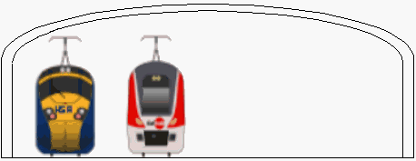
Note: Clem Tillier, who owns the Caltrain-HSR Compatibility Blog, kindly contributed artwork to this post. Unfortunately, I'm artistically challenged but I hope the cross-section drawings help to get the idea across.
 In a follow-up to Thursday's welcome news that Palo Alto officials are waking up to the potential downsides of letting tunnel boring machines into suburbia, this post presents a possible alternative implementation for HSR in the mid-peninsula that may also be of interest elsewhere (e.g. Fullerton-Anaheim-Irvine). It seeks to minimize local environmental impacts, i.e. visual clutter, noise, vibration, re-configuration of cross-roads and changes to established road traffic patterns. This does involve some trench construction, but digging can't be avoided if above-grade solutions are deemed unacceptable: wherever grade separation is required, either the roads or the tracks will have to descend.
More detailed studies will be required to decide which is preferable, but my hunch is that the 150-year railroad ROW might actually be the easier of the two options, as existing plumbing, gas, telephone and utility lines will at least be documented more accurately and may anyhow run deeper to avoid vibration damage.
Before I delve into the gory details, allow me me clarify a few things up front:
- The suggestion described below is my own, it does not come from CHSRA nor their consultants for this segment (HNTB). My objective is to discover what is and what is not acceptable to residents of the mid-peninsula towns of Redwood City, Atherton, Menlo Park, Palo Alto and Mountain View. No sleight is intended to residents of other peninsula towns, that's simply the geographic scope I selected to illustrate the concept.
- I've assumed that CHSRA will win the pending court case regarding the EIR/EIS process and, that it will secure the ROW to Gilroy needed to implement its preferred route (as in: not mine).
- Implementing this would be a good deal more expensive than the original proposal of a retained fill embankment. The funding gap would need to be quantified and appropriate financing negotiated. CHSRA is having enough difficulty scraping together the ~$33 billion it has already estimated for the starter line. That means any solution that goes well above-and-beyond would require that cities tax themselves and/or rustle up other funds not already available to CHSRA.
It's also worth looking HSR implementation (pls zoom in) in the peninsula as a whole. For example, it's not immediately obvious why CHSRA is proposing a tunnel between San Tomas Expy and San Jose Diridon station, so local officials should ask for an explanation and request an alternative if appropriate. This may involve co-operation and cor-ordination with other peninsula communities and multiple railroads, but that should not preclude an attempt at overall optimization. Even if that succeeds, there still has to be some element that will keep every town and hamlet along the route from seeking upgrades or else, cost escalations will sink the entire HSR project very quickly indeed. That's not an acceptable strategy for mid-peninsula cities to pursue. - Unfortunately, HSR construction will be a noisy, messy affair pretty much regardless of which option is chosen. It may be possible to phase construction such that there are always two tracks available for Caltrain and heavy freight trains. However, the work might proceed faster and at lower cost if the old single-track Dumbarton rail bridge were restored first so UPRR's Mission Bay Hauler trains could be diverted, perhaps permanently. This would be at their option, since they have a limited easement on the Caltrain ROW - even a say in who else gets to use it! During critical periods in the construction schedule, Caltrain could maintain some limited SF-SJ service via temporary trackage rights on UPRR's Alviso line and also offer temporary bus services via Central Expressway/Alma/El Camino Real.
Considering its western trestle and approach burnt to a crisp in a suspicious fire in 1998, restoring this 100-year-old bridge would be a marginal proposition at best (and one CHSRA has not budgeted for). After HSR construction, a restored bridge could support UPRR, a few Caltrains across to Union City, perhaps even a new ACE service up to SF - figure around half a dozen trains each way per day. Note that replacing the bridge with a new dual-track causeway with bascule sections would be preferable for seismic and fire safety alone, even if it is only ever used for a limited volume of freight and commuter rail/Amtrak. Basically, the decision hinges on how much construction near and rail traffic through the DENWR (founded in 1974) will be permitted at all.
Sadly, the idea of running dozens of HSR trains through there at grade each and every day is almost certainly a non-starter. If the Altamont HST/commuter overlay ever gets built, CHSRA's plan is to run regional high speed trains down to SJ Diridon, not across Dumbarton and up to SF. This is why - for better or worse - I'm sticking with plan A here and trying to contribute to the process of finding an acceptable solution.
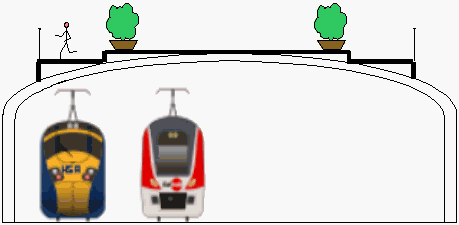
In a nutshell, what I'm suggesting here for the mid-peninsula is to build an enclosure for all four tracks to minimize visual clutter from the overhead catenary system and especially, to keep bow wave and noise emissions isues to a minimum - even for trains moving at 125mph. At grade, the enclosure would be composed of two sides and a lid. The outside width of the enclosure would be 75 feet.
To conform to AAR specifications for tunnels, the sides would be 18' tall and then continue up along an arc. The definition of where the sides end and the lid begins is up to the architect. They would consist of a slender latticework of steel I-beams encased in concrete for protection against rust and fire, rather than conventional rebar.
The spaces in-between would be filled with large soundproof glass panes (possibly sandwich structures), probably triangular with rounded corners. These would be embedded in the latticework using a visco-elastic putty/dense foam interface to minimize stresses in the glass membrane in response to temperature, wind and earthquake loads. An example of how large glass panes can be supported securely yet flexibly is the mile-long terminal building at Kansai Airport near Kobe (Japan), which has withstood subsidence, typhoons and a major earthquake without damage to its glass skin.
However, the use of large glass panes would preclude the use of regular ballast, as small pebbles propelled by the aerodynamic forces of passing trains could damage them. The rails, too, can be damaged by ballast pitting. Instead, the concrete sleepers would be attached directly to a concrete foundation slab. A promising new Japanese approach based on ballast bags filled with a special non-toxic aggregate made from recycled materials could be applied to dampen rail-wheel noise beyond what the enclosure alone would achieve. Damping is most effective for medium and high frequencies, but those are the ones that the human ear is more sensitive to.
The idea is to create an airy, largely transparent structure with rounded edges along the top. This should massively reduce the claustrophic effect a tall solid embankment can have, something even an interesting surface texture cannot fully overcome. Thanks to the large glass panes, the result would be more like a giant version of what the French call a vitrine, showcasing products at a store or artifacts in a museum. Both metaphors seem apt, considering that passenger trains played such a vital part in the state's past and will do again soon. Peering through the glass, you would be able to see the trains passing but should hear no more than a quiet low rumble. That's because the lid eliminates virtually all direct transmission paths through the air, much like closing a door will greatly reduce noise coming from an adjacent room. The visco-elastic putty will permit the glass panes to move and even flex slightly in response to the bow waves of passing trains, lending the whole structure the grace of a subtle kinetic sculpture.
The lid would implement the circular arcs required by AAR for the walls of the outside tracks (used for HSR?) plus the relatively flat center section in-between. However, since the Caltrain/HSR tracks will need a couple of feet of additional vertical clearance anyhow, the wide span of the structure could perhaps be supported as a vaulted ceiling, completely eliminating the visual clutter of internal columns.
One stunning example of this concept is found at Santiago Calatrava's beautiful Satolas TGV station, located next to the regional airport in Lyon, France.
Ironically, the very success of the TGV service ended up depriving the airport of customers for domestic flights. Note that the Satolas station is much wider and taller than what I am suggesting for the mid-peninsula and, that its sides are open to the elements. Nevertheless, I hope the comparison gives you a sense of what a skilled civil engineer-cum-architect can accomplish. That said, pulling off a vaulted ceiling 75' wide would be a bit of a challenge in earthquake country.
The underside of the lid would be used to suspend the overhead catenary system or perhaps, space-saving overhead conductor rails from Switzerland that support speeds of up to 150mph, certainly good enough for Caltrain/UPRR use. There would be no need for the usual catenary poles.
In spite of the slender latticework, the rounded edges, the vaulted ceiling and the glass panes, the enclosure concept still implies a large above-ground structure, roughly 75 feet wide, ~28 feet tall in the center and literally thousands of feet long. Inevitably, it would dominate its surroundings, so it's not appropriate in all locations. As indicated above, it would also cost a pretty penny. Unfortunately, selling air rights above it to developers wouldn't be a viable option.
The Linear Park
That is why I'm suggesting that the upper side of the lid be leveraged for an elevated linear park serving the community, with the objective of boosting - rather than blighting - the values of nearby properties. Many options exist: if the edges of the enclosure are curved as suggested above, the park could be confined to the central portion of the ROW or feature cantilevered outriggers or both, to suit local requirements.
Many linear parks already exist, e.g. the new Highline in New York and the Promenade Plantée in Paris:
Both of these leverage abandoned elevated railroad rights of way, rather than the space above active tracks. However, Seattle's Freeway Park, Sam Smith Park and the Lid Park on Mercer Island (WA) are all built on top of major active transportation arteries. More recently, President Sarkozy of France has invited suggestions for yet another expensive grand makeover for that country's capital. Richard Rogers' entry would create park spaces above active railroad tracks and yards, though the scope of that is far more ambitious than what I'm proposing here.
In addition to safety railings, there might be value in installing bowers and pergolas to support climbing plants that provide shade and provide some formal structure at a human scale, cp. the Promenade Plantée video above.

Load restrictions at existing road underpasses may force architects to narrow the linear park to just a foot/bike bridge across a lightweight lid section that could be an architectural flourish or a more delicate feature spanning a (very) shallow pond or trompe-l'œil mural.


Trench Sections
In some parts of the alignment, the most appropriate solution may be to force the tracks to descend into a deep trench so they can pass under existing cross streets, to avoid vehicle access impacts to buildings along the first block to either side and/or intersections with frontage roads. Such constraints are more common where residential properties directly abut the Caltrain ROW. Note that trench walls require a certain thickness but that the lid structure would serve as a buttress. Engineers will have to work hard to fit it all into just 75 feet of width, but it ought to be possible.
The enclosure and the linear park above it would follow the elevation change of the tracks. Obviously, the latticework side walls would be replaced with solid concrete below grade level. In these trench sections, the park would actually run 2-3' above grade to support lush vegetation, e.g. using recycled water. The sides would be retained with heavy wooden beams or else sloped as a 2:1 embankment. Either way a suitable fence and/or hedge would be indicate the property line, that's a detail to be resolved at a later stage. Because edges of the lid would still curve down to the sides, there would be plenty of soil to support large shrubs and small to medium-sized trees. Bike and pedestrian paths would slope down toward cross streets unless traffic planners, civil engineers and landscapers decide that very low hump bridges would be preferable, e.g. to reduce excavation depth. Playgrounds, fitness parcours or (lightweight) outdoor sculptures might be appropriate in one location, perhaps a serene Japanese pagoda with water features and a rock garden in another. Again, plenty of scope for customization at the city or neighborhood level.
Optionally, tall graceful arches could be installed in some of these sections of the park to provide a visual frame of reference, support wire trellises and/or enhance outdoor lighting.


Ventilation
Along the entire length of the structure, there will be a need for ventilation funnels at regular intervals. These should be shaped to direct sound upward and feature a grate/net to prevent objects from falling in (or being lobbed in). If any train operator insists on running diesel locomotives through the structure, the funnels should feature quiet fans. Note that extremely strict EPA Tier 4 emissions regulations will be in force by 2015, these should be used in this enclosed structure.
Track Elevation Transitions
Here is where things get a little technical, feel free to fast forward to the next section if you're not so inclined.
The following map shows which sections of the Caltrain ROW I would recommend be left at grade (blue) and which might best be put in a deep trench (red). The green sections represent elevation changes. In cross-section, these S-ramps consist of vertical arc segments, typically connected by a straight slope segment. Note that these transitions are not identical for the Caltrain/UPRR and the HSR tracks. Freight trains are limited to slopes of 2.2%, whereas HSR trains can negotiate 3.5%. On the other hand, Swedish and German design guidelines recommend vertical curve radii of 6400m and 10000m, respectively, at 125mph. Tighter curves can be used at lower speeds.
Note that some of the existing road underpasses may have been designed for just two tracks, just like those up in San Carlos. The bridges for the additional tracks on either side may therefore have to be elevated a little to maintain vertical clearances for tall road vehicles. I've allowed up to 2' difference in elevation at these points, which should be plenty. The upshot is that the inside and outside tracks would run at different elevations in a number of locations, limiting where the extra-long turnouts for baby bullet operation at 90mph could be placed.

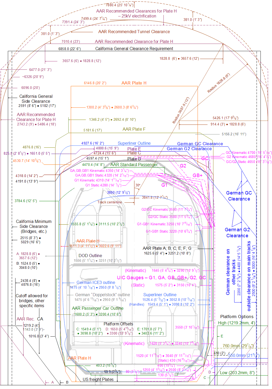
The minimum vertical clearances are spelled out here: 24'3" for the Caltrain/UPRR tracks and 22'6" for the HSR tracks. Note that there is no need for an additional 1'3" electrical clearance in this case as the HSR tracks are not ever supposed to be used for AAR plate H freight cars. I assumed an additional 4' would be needed for the support structures of the short (75') road bridges at rail underpasses, with the additional option of support columns if fully-loaded 18-wheelers (80,000lbs GVWR) are to be permitted.
The Google Map
I've crunched the numbers in a spreadsheet, without any spiral easements in this first cut. The whole thing has ended up resembling a very gentle rollercoaster.
View Larger Map
Churchill Avenue: Rail Underpass
Only between Embarcadero (an existing road underpass) and Churchill Ave (which should ideally remain at grade) in Palo Alto is the transition a really tight fit. Caltrain would remain limited to 79mph at that one location, which is not a problem since all of its trains stop at University Ave anyway. HSR trains could run at 125mph (Swedish rules) or have to slow down to 103mph (German rules) - the difference stems from the passenger comfort thresholds maintained by these national railroads, rather than safety considerations.
Palo Alto Avenue: Road Underpass, Chicane
The Palo Alto Ave (Alma St) grade crossing is located between San Francisquito creek and the University Avenue Caltrain Station. Since both of those needs to be negotiated at grade, a deep road underpass is unavoidable in the context of this scenario. Given the proximity to the delicate root system of the venerable El Palo Alto coastal redwood tree, moving the road crossing south a little bit might be worth considering. That might also mitigate the impact on the connection for the eastern part of Palo Alto Ave. The 100-year-old railroad bridge across the creek should be replaced for safety reasons. Its replacement should support four tracks at grade and be located further from the tree, to protect its roots during construction. Worst case, the tracks could run on a low viaduct (1-2') to avoid exerting any pressure on the root system at all. The resulting crawl space could be filled up with loose earth if desired.
A fringe benefit of moving the tracks will be that the curve radii at the north end of the Palo Alto chicane will be eased somewhat. Doing so at the south end would also be appropriate, if the land can be obtained at reasonable cost. Easing the chicane would avoid a much more intrusive rectification of the Alma/University grade separation. Leaving the chicane in place would force express trains to slow to about 85mph, adding a full minute to their SF-SJ line haul time. If CHSRA selects Palo Alto University Avenue for the mid-peninsula HSR station, at least one straight 400m (1/4 mile) platform will be required, forcing a more significant redesign of the alignment. Both Redwood City and Mountain View are viable alternatives.
Honorable Mentions
In several locations, creeks and storm drains would have to be diverted underneath the tracks. In at least the latter case, regular cleaning would be required to prevent a build-up of debris and a risk of local flooding on the upstream side.
From north to south:
- in Redwood City, the section between Woodside Rd and 5th Ave should remain at grade on account of the existing grade separations, the Dumbarton wye and the Hetch Hetchy aqueduct that provides the peninsula with drinking water.
- in virtually all of Atherton and Menlo Park, the tracks would run in a deep trench, an implementation both cities requested of CHSRA.
- in north Palo Alto, tracks would run at grade everywhere except for the rail underpass at Churchill. This may or may not avoid conflicts with a toxic plume and an emergency aquifer, I'm not sure where they are located exactly.
- in south Palo Alto, both E Meadow and Churchill would remain at grade.
- San Antonio Caltrain station would still be at grade as well, but HSR tracks there would have to run underneath the Caltrain platform(s), as both the ROW and the San Antonio overpass are too narrow to support four tracks plus two platforms. That means a pedestrian overpass will be needed to reach the platform(s) - not much of an eyesore considering it will be right next to the road overpass. Also, the enclosure could be narrower between Charleston and Rengstorff, since only two of the four track would rise back to grade level. That would leave scope for bike/pedestrian paths, trees or elongated shallow water features at grade level, with spectacular lighting effects.
- in Mountain View, Castro Street and VTA light rail tracks mean that Caltrain/UPRR and HSR will need to run in a trench. Rengstorff Ave is a poor candidate for a road underpass, so the caltrain/UPRR tracks would remain underground for a total of ~2.2 miles. HSR tracks would run in a deep trench all the way from E Meadow to just north of 237.
The anyhow needed long trench in Mountain View would open up the possibility of an underground HSR/Caltrain station there. The city has recently requested that CHSRA study the possibility. IMHO, it might actually be a lot easier to put one there than at University Ave in Palo Alto. The Arroyo del Agua creeks would make an elevated alignment preferable in Redwood City, so an HSR station there would dominate the skyline.
In Mountain View, the Caltrain ROW could be widened underneath Central Expressway, with temporary lane closures during the construction period. Platforms would be reached via not one but three pedestrian underpasses, on account of the 1/4 mile HSR platforms. These would be two levels down, connecting West Evelyn to Willowgate. In the long run, the greatly enhanced property values on the far side of Central Expressway might merit rezoning for mid-to-high-rise mixed-use developments. Bike grooves next to stairs are always highly recommended in pedestrian underpass designs.
VTA light rail would remain at grade but be upgraded to dual tracks, with the option to extend service out to Rengstorff. This would be at the expense of the linear park feature but serve the senior center and create some room for overnight parking. A new line from Mountain View to Alum Rock would be possible, as would stairs/elevators from either Caltrain or HSR directly to the VTA platform(s).
In addition, a new streetcar loop service based on ultra-low floor (ULF) rolling stock could connect the downtown area (popular lunch destination, candidate for a small pedestrian zone?) to Shoreline business park/amphitheater with a yard east of Crittenden Lane. If the VTA line is extended, tracks for the two services would cross at right angles on Castro Street.
Most buses could continue to stop at W Evelyn, though city traffic planners could leverage the pedestrian underpasses to make auxiliary stops on the far side of Central Expressway (Willowgate, Moffett) potentially viable. A southbound bus lane from Rengstorff to just past the VTA turnoff on top of the tracks could also help avoid congesting in the downtown area.
Vitrine Entrance/Exit
Given the no doubt hefty premium an enclosure/trenching and a linear park would command, it's very likely that some peninsula cities will choose an uglier but cheaper option for HSR implementation, e.g. a Japanese-style viaduct with sound walls. However, the transition from open to enclosed track sections will be much like a tunnel entrance and should therefore be sloped and beveled to minimize any impact on the lateral stability of the trains and tunnel boom. The following example illustrates the residual effect at 186mph. Please note that all of the sounds you will hear would be less pronounced at the lower top speeds (90-125mph) applicable to the peninsula.
